In environmental investigations, the relationship between the mark you put on the map and the physical location where a boring is drilled in the field can be tenuous. This can be addressed by doing a thorough initial survey before finalizing your plans (take lots of photos!), but sometimes things change. For example, the local utility-marking organization comes out a day or two earlier and shows that you have a rat's nest of lines right where you want to drill. Or you didn't look up, so you didn't see that a drill rig's mast would get completely tangled in the understory of the massive tree near your location.
Drill rigs can reach places you may not expect (fond memories of drilling on scary-steep slopes!), or may get hung up in places you didn't expect, either. And trees can blow over and random cars can get parked for days unexpectedly. So when preparing for an investigation, it's always best to clear a much larger area than you think you'll need, so you have the option of moving around... or if not, then having some flexibility with your drilling schedule so you can get the easy stuff first while you wait for new locations to be accepted and cleared.
Most of the time, moving over 5 or 10 or 20 feet doesn't impact the data you collect. If you have an especially small site or you're trying to place sentinel wells on the property boundary, you have less room to maneuver.
However, I've worked on a few bedrock investigations where we were trying to target specific fractures. Usually we'd do surface geophysics (usually some combination of seismic, ground-penetrating radar, electromagnetic, or electrical conductivity/resistance studies) first to find potential water-bearing fractures, then we'd tag a particular spot for drilling. Drill rig access often didn't enter into it.
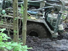
So that was how I found myself (and the driller) staring at a little pinflag next to a boulder, between two giant trees, in a saturated wetland. After a few phone calls, it was established that the fracture was close to vertical, so we couldn't just move over to intercept it a little deeper, and the signal petered out not very far away. After winching the drill rig in, supplying a breadcrumb trail of concrete blocks to stand on, and doing some amateur aerial branch cutting, we drilled... a dry hole. The technical lead asked if we had actually drilled on the exact correct spot. Well, not prescisely the same spot. Anyway, my bacon was saved when we did further investigation and established that we had actually intercepted what appeared to be the correct fracture. It just wasn't transmitting the water it was supposed to.
Always keep in mind that we have control over lots of different variables in environmental investigations. But we do not control the geology.
Subscribe to:
Post Comments (Atom)
No comments:
Post a Comment